
 Geohazards
In the aftermath of the tragic Indian Ocean tsunami and earthquake in 2004, an international tsunami monitoring initiative was launched.
On 26 December 2004, huge geological forces that had been building deep in the Earth’s crust were suddenly released under the Indian Ocean, close to the Indonesian island of Sumatra. The event triggered one of the biggest earthquakes ever recorded, causing hundreds of square kilometres of the seabed to violently shift upwards and sideways, generating a tsunami that swept away several communities around the Indian Ocean.
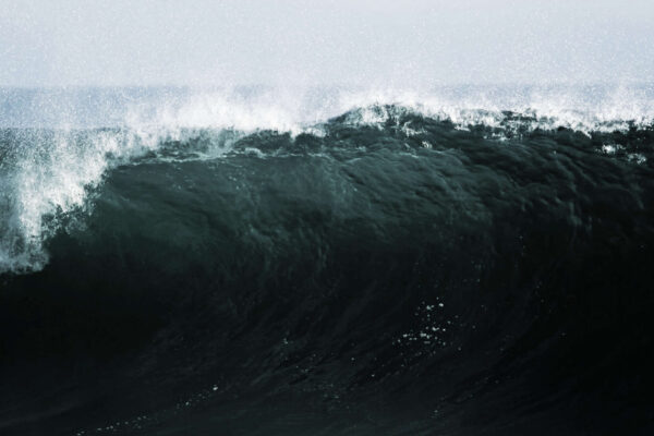
As the seabed puckered during the 9.1 magnitude quake, it displaced immense volumes of seawater, producing waves that raced across the ocean in all directions, like the ripples when a rock is thrown into a lake.
In the devastation that followed, nearly 230,000 people were killed and 1.6 million made homeless, with countries including Indonesia, Sri Lanka, India, the Maldives, and Thailand sustaining harrowing damage.
People drowned at sea, on beaches, in streets, and in their homes. In some areas, waves swept kilometres inland, destroying almost everything in their path. Ill-equipped and unprepared, lack of warnings or evacuation plans left much soul searching about how countries could better prepare for future tsunami events.
The catastrophe galvanised countries across the region to develop a tsunami warning system for the Indian Ocean, under the coordination of UNESCO’s Intergovernmental Oceanographic Commission (IOC). Inspired by programmes operating since the mid-20th Century in the tsunami-prone Pacific Ocean, the Indian Ocean Tsunami Warning and Mitigation System (IOTWMS) relays information to 27 national tsunami warning centres in the region.
Now, the challenge is to maintain and improve the system, and ensure communities around the world are better prepared for these rare, yet devastating events.
System of systems
“You can’t predict earthquakes, but by using real-time seismic and ocean observations you can anticipate how tsunamis might develop in the following minutes and hours after an earthquake,” says Srinivasa Kumar Tummala, Director of the Indian National Centre for Ocean Observation Services (INCOIS), Hyderabad, which provides tsunami alert services to vulnerable coastal areas nationally and internationally. “Had warning systems been in place, and communities better prepared during the 2004 Indian Ocean Tsunami, many lives could have been saved.”
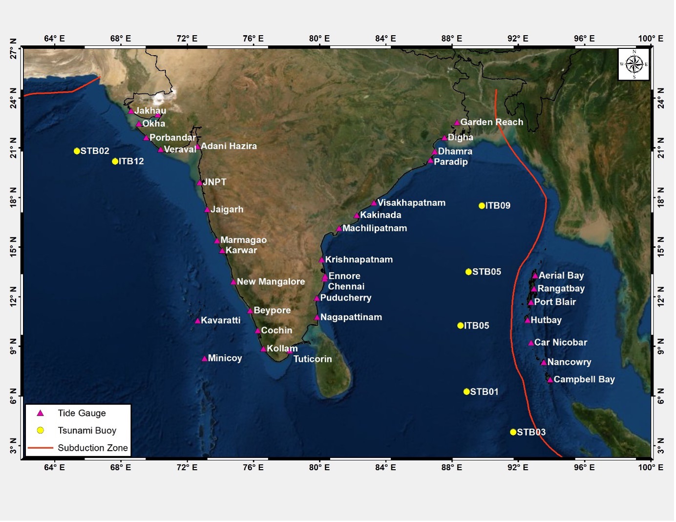
Tsunamis are relatively rare events, with only around 125 fatal tsunamis on record worldwide since 1900. Yet the 2004 catastrophe, and others since, have shown that tsunamis can occur almost anywhere in the Ocean at any time. As one of the organisations responsible for leading tsunami warnings in the Indian Ocean region, INCOIS operates 36 tidal gauge stations and, together with India’s National Institute of Ocean Technology, seven tsunami buoys that provide cover for India’s entire coastline, extending more than 7000 kilometres.
INCOIS also hosts the Indian Tsunami Early Warning Centre, which is responsible for issuing tsunami advisories and contributes to the Indian Ocean Tsunami Warning & Mitigation System, one of 11 tsunami warning centres that make up the IOC’s Global Tsunami Warning and Mitigation System.
“To deliver effective tsunami warnings, one of the biggest challenges is to improve sea-level monitoring in near-real-time,” Tummala says.
“Tsunamis are quick-trigger events, and fast transfer of data is essential to confirming the generation of tsunamis, monitoring their propagation, and predicting their arrival times.”
Therefore, one branch of the system involved developing dedicated infrastructure, which both expanded observation capacities and channels to get the data to the right places, fast. “This included the establishment of seismic stations for earthquake detection and expansion and upgradation of our network of tide gauges, which are positioned in coastal locations and fitted with sensors that continuously record the height of the surrounding water level,” Tummala says. “We also positioned sensors in the deep ocean that can detect tsunamis by measuring seafloor pressure, which is relayed to buoys on the surface and then onto land via satellites.”
A second branch involved filling in fundamental gaps in tsunami hazard and risk knowledge. “Around three-quarters of tsunamis are caused by large undersea earthquakes, while the rest are caused by submarine landslides, volcanic eruptions, and meteorological phenomena,” says Tummala. “One way to better understand where tsunamis are likely to be generated is to map past earthquake data. Studies of earthquake data from the past century revealed two main hotspots in the Indian Ocean, one off the Andaman-Sumatra subduction zone in the eastern Indian Ocean and other off the Makran subduction zone in the northern Arabian Sea – where one tectonic plate is sliding beneath another.

“We also needed better maps of the seabed, bathymetry, and coastal topography – an immense undertaking that was carried out by experts using airborne and other in situ measurements. In the deep ocean, tsunami waves may be barely noticeable, but they travel at immense speeds comparable to that of a jumbo jet – around 500 to 1000 kilometres per hour. As the waves hit shallower waters, they slow to tens of kilometres an hour, increasing in height and potentially forming large, destructive deluges.”
Knowing when and where bigger waves might hit is key to issuing effective warnings, effects that can be simulated using computational modelling techniques that integrate the broad suite of ocean observations.
“We then started with the person on the beach,” Tummala explains. “The first question is: how much time have they got? For earthquake-induced tsunamis, the answer largely depends on how far away from the coast the event happens and the depths of the ocean in between.
“If a tsunami is generated along the Andaman-Sumatra subduction zone, this means that tsunami waves could be two to three hours away from striking the Indian mainland.
“Yet for regions closer to the source – including India’s Andaman and Nicobar Islands – these timescales are shortened to just 15 to 20 minutes.”
This leaves just a very short window of time to piece together data, establish whether an earthquake might trigger a tsunami, and relay the information to authorities so that people have time to get to safety.
Tsunami bulletins
The Indian Tsunami Early Warning System was launched in 2007 and one of its biggest tests to date came on 11 April 2012, when powerful twin earthquakes with a magnitude 8.5 and 8.2 struck off the coast of northern Sumatra.
“The tremor initially bore many of the hallmarks of tsunami-generating earthquakes: massive in size, shallow in depth, but being a strike-slip earthquake it eventually ended up creating a wave of around a metre in height close to the source,” Tummala says. “Seismological, sea level, and other observational data across the Indian Ocean was analysed and warnings and alerts were issued to national emergency authorities.
“The Andaman and Nicobar Islands were in very close proximity to the earthquake, and we immediately sent out an advisory to the islands’ authorities to coordinate an evacuation along their coastlines. This was a very worrying time for communities, many of whom were still recovering from the devastating event in 2004.
“For the Indian mainland, however, the timescales were longer, so we issued a heads-up that authorities should be on alert for our next bulletin, to clear their beaches, but to wait for more information before ordering a full-scale evacuation.”
Experts at INCOIS then turned to pre-run computer simulations available across the entire length of the Andaman-Sumatra subduction zone – which stretches some 5,600 kilometres from Myanmar to the Lesser Sunda islands – and compared these situations to the inflow of near-real-time data from the tsunami observation network.
“As soon as we detected that a powerful earthquake had struck, we selected the closest scenario from our database, initially assuming a worst-case situation,” Tummala says. “When more observations became available, we could rerun the simulations incorporating this new information, comparing our worst-case scenarios to how things were playing out in reality.”
After carefully analysing sea level observations and considering the revised earthquake data and model simulations, when it came to issuing a follow-up bulletin, experts concluded – to wide-spread relief – that no significant tsunami threat remained and no evacuations were needed in the main land coastal areas.
“At this stage we were able to provide a ‘threat passed’ bulletin,” Tummala recalls. “Authorities must strike a delicate balance: not all earthquakes generate tsunamis, and they cannot just keep evacuating communities when there is none. Due to the complex nature of tsunamis, especially for non-seismic sources and near-source events, it is important to understand that there will be uncertainties in our initial predictions, and accordingly build operational procedures and public awareness and response plans.
“Future work is focused on enhancing the end-to-end tsunami warning system through a combination of better risk assessments, enhanced observational networks, modelling & forecasting methods, warning communication, community preparedness, awareness and response.”
One of the key aims of the IOC’s Tsunami Unit over the next decade is to narrow down those uncertainties – approaches that require expanded observation networks and improvements in community preparedness.
“One aspect includes improving alerts not just for tsunamis caused by vertical displacements of the Earth’s crust, but also for other triggers,” says Bernardo Aliaga, head of the UNESCO Intergovernmental Oceanographic Commission’s Tsunami Resilience Section.
“Warning systems such as the Indian Ocean Tsunami Warning and Mitigation System are mature in the sense that components including observing, monitoring, detecting, developing information products, and community preparedness are broadly in place for tsunamis generated by the movements of tectonic plates.
“But for events that are not generated directly by an earthquake, such as volcanic eruptions, underwater landslides, and even tsunami-like sea waves of meteorological origin, we still need to go the extra mile in the Indian Ocean and elsewhere.”
Such events make up around a quarter of all tsunamis. A recent example Aliaga points to is a devastating localised tsunami that hit Palu, Indonesia in 2018, that some experts believe resulted from underwater landslides triggered by a large strike-slip earthquake that claimed the lives of nearly 4,500 people. Another is a series of tsunamis that propagated across the Pacific Rim in 2022, caused by the eruption of the Hunga Tonga-Hunga Ha’apai underwater volcano.
“Moreover, experts say climate change is increasing the likelihood of landslide-generated tsunamis in parts of the world that previously had very few, such as the southern Atlantic Ocean” Aliaga says. “To close this gap in observations requires an expansion of global networks, the establishment of new ones in regions currently not covered, and better community preparedness.
“One aspect relates to our capabilities to detect such tsunamis. But another comes down to coordination between different groups and authorities at an international level. For instance, while protocols have been established to warn civil aviation and other critical services when volcanic activity happens, there is a gap in effective links between volcano observatories and tsunami warning centres. This is something we are working hard to change.”
One of the aims of the UN’s Ocean Decade Tsunami Programme is to bring together diverse contributors such as seismologists, oceanographers, modellers, practitioners, emergency managers, and representatives from local communities to explore and define ways to improve tsunami warning and response in the coming years.
“A tsunami is not a point, it’s an extension driven by complex hydro-dynamic phenomena and mechanisms,” Aliaga says.
“This means that sometimes it is not the first wave that is the most dangerous but, because of the coupling forces of the receding wave with the incoming wave, the second, third, or fourth wave can be the most deadly.
“If you have just one sea level station in a city that was destroyed, then you get blind. This is why it is so important to have a network of sea level stations that provide warning centres with the information needed to advise authorities that it’s now safe for emergency responders to enter flooded areas and start the recovery process.
“In the past, running simulations could take hours, but over the past decade technology has developed to a level where models can run in just a minute and half using graphics cards on an ordinary computer. This puts us in a great position, but we need to do more.
“After the 2004 Indian Ocean earthquake and tsunami, tragic stories emerged of bystanders lingering on exposed beaches and emergency response teams being overwhelmed by subsequent waves. But there were also inspiring stories of people who used their knowledge of tsunamis to lead people to safety. One of our primary goals is to develop ways to empower communities to take ownership of the evacuation and recovery process.”
One example is the IOC’s Tsunami Ready programme, an international community-based recognition programme that aims to build resilient communities that meet a standard level of tsunami preparedness through the fulfilment of a set of established indicators.
“There are a series of steps that can support community response,” says Aliaga. “These include the availability of detailed tsunami hazard maps of the area, highly visible and labelled evacuation routes, regular drills that prepare communities for an actual tsunami, and the development of warning systems that make use of diverse communication means such as SMS, radio and television broadcasts, sirens, and loudspeakers.
“The risk of tsunami is underestimated in most areas. As events are not very frequent, the awareness of the risk does not pass from one generation to another. But the threat is very real, and the challenge remains to be vigilant and to close gaps in preparedness.
“Tsunami Ready recognition does not mean that a community is tsunami proof, however it does indicate that the areas have adopted mitigation measures to cope with their tsunami risk – looked at the certainties and uncertainties, know what to look for, and what to do – with or without warnings.
“In some tsunami events, the sea may recede tens of metres before waves hit the coastline, while in other events this may not happen at all. There may be a deluge, or other signs such as the earthquake itself and loud roaring noises. When the worst case happens, we want to empower people to take ownership of this process.
“There is still work to do – especially in bridging geopolitical factors and supporting less developed countries and small island states. On the other hand, we have come a long way since 2004. We are safer today. I find it personally very inspiring to see the strength of local coordination and willingness of people around the world to take charge of their own safety.”
Figure 1: Subduction zones in the Indian Ocean. The Andaman-Sumatra Subduction Zone extends from the Himalayan front southwards through Myanmar, Andaman and Nicobar Islands, Sumatra, Java, and the Sunda Islands (Sumba, Timor), to the north of Western Australia. The Makran Subduction Zone lies between southeastern Iran and southwestern Pakistan
Figure 2: Indian sea-level observation network of tide gauges and tsunami buoys. The Indian Tsunami Early Warning Centre receives data, in near-real-time, from stations covering the entire Indian coastline as well as from those operated by several other countries all over the globe. In kind, the data from eight tide gauge stations and seven tsunami buoys are shared in near-real-time with the international community. The sea-level data received are used to monitor the progress of tsunami waves and the wave amplitudes and complement in refining tsunami advisories.
Written by Adam Gristwood
With thanks to Srinivasa Kumar Tummala (INCOIS) and Bernardo Aliaga (UNESCO)