The Partnership for Observation of the Global Ocean (POGO) was founded in 1999 by directors of oceanographic institutions around the world as a forum to promote and advance the observation of the global ocean. POGO is a UK-registered charity with member institutions from around the world, and works closely with other international and regional programmes and organisations.
POGO seeks to expand international support for ocean observing, through innovation of the ocean observing system, capacity development and outreach/advocacy.
Despite having been regarded as seismologically stable for more than 4000 years, earthquake swarms, peculiar surface oscillations, and the birth of an undersea volcano has put Mayotte, a French overseas territory in the Indian Ocean, on high alert. Ocean observations could help develop warnings and unlock secrets of volcano dynamics.
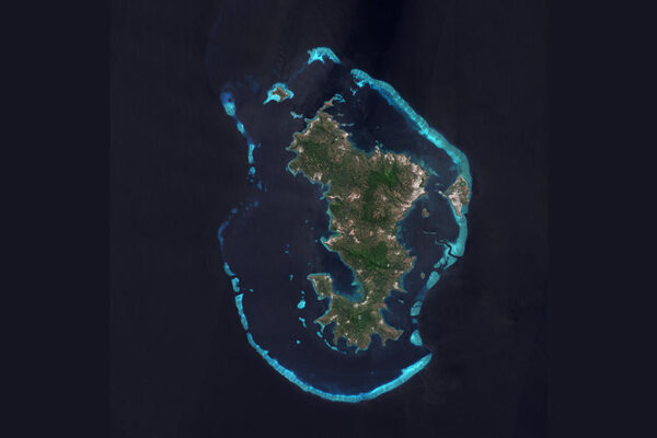
L'ile de Mayotte dans l'ocean indien, vue par le satellite Sentinel-2, le 14 aout 2021.
Mayotte est un archipel de l'ocean Indien situe entre Madagascar et la cote du Mozambique. C'est un departement et une region francaise, meme si la culture traditionnelle de Mayotte est plus proche de celle des iles Comores voisines. L'archipel de Mayotte est entoure d'une barriere de corail qui abrite un lagon et une reserve marine, destinations tres courues pour la plongee.
On the morning of 11 November 2018, seismologist Pascal Bernard woke up to a string of messages from colleagues.
Dozens of seismologists around the world were puzzled by a highly unusual seismic observation reported on social media and were fervently discussing its possible origin.
Seismograms in places as far flung as Nairobi, Auckland, Hawaii, Tokyo, and Santiago had recorded a long, slow oscillation in the Earth’s surface that had persisted for nearly an hour.
However, despite the seismic rumblings being powerful enough to trigger instruments spanning the entire planet, there had been no reports anywhere of a major earthquake.
“My mind raced through numerous possibilities: a meteorite, volcanic activity, or perhaps something else? We simply didn’t know,” recalls Bernard, a senior researcher at the Paris Institute of Earth Physics (IPGP), France.
“For surface waves to be recorded at a global level at this size and frequency was very unusual, and a lot of people immediately started looking into what they could be.”
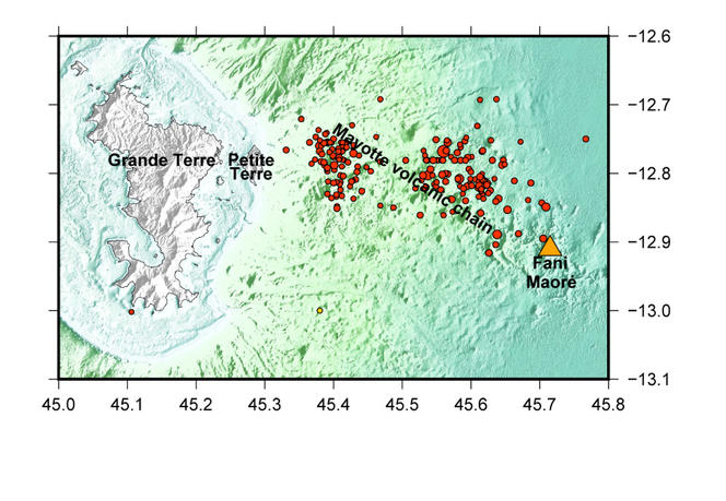
Seismic surface waves travel at speeds in the order of kilometres per second – and with the waves arriving at different locations at different times, scientists were able to co-locate them to a region off the coast of Mayotte, a French overseas territory nestled between Madagascar and Mozambique in the Indian ocean.
That was until a swarm of earthquake activity began some six months earlier.
State of high alert
“In May 2018, Mayotte had been shaken by a series of quick-fire earthquakes that many experts suspected were related to volcanic activity below the seabed, with local seismograms triggered almost on a daily basis during the following months,” Bernard says.
“There were other troubling signs: local fisherfolk had reported hordes of dead fish and a strong smell of sulphur at sea. GPS observations, on the other hand, indicated that the entire island had shifted eastwards by around 20 centimetres and its eastern shoreline had been subsiding by several centimetres.
“Seismic activity on Mayotte had previously been very rare, with only a couple of events recorded since the 1970s.”
The sudden increase in activity caused considerable concern amongst the island’s population, some of whom reported worry and sleepless nights.
“When we saw that the seismic event on 11 November stemmed from the region, we immediately suspected volcanic activity was to blame,” Bernard says.
“The exact cause of the global oscillation event remains a mystery – it could be the result of the collapse of a magma chamber under the seabed, or stem from the rapid flow of magma from one chamber to another.
“However, of more immediate concern were the implications that this flurry of unusual seismic activity might have for the people of Mayotte.”
In response, French research organisations teamed up on a range of ocean observation initiatives that aim to better understand the situation and potentially develop warnings.
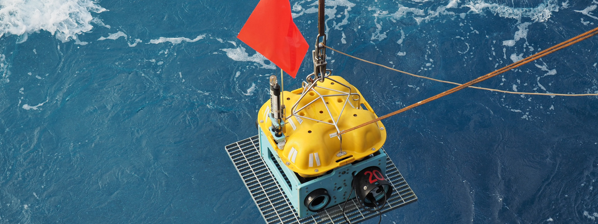
One arm of the research has seen oceanographic expeditions visit the region, delivering a multitude of diverse ocean observations across an area of seafloor spanning some 8,500 square kilometres.
“One vessel that was commissioned is the Marion Dufresne, which is amongst the largest research ships in the world,” Bernard says.
“The boat has space for more than 100 scientists and crew, lab facilities, echo sounders, winch systems for handling heavy equipment, and a unique system able to take large samples of seabed sediment from the deep ocean.
Fig 1
“During the ship’s first visit to the region, seismometers were carefully installed at depths of 1.5 kilometres – close to the main areas of seismic activity – to enable scientists to gather a better understanding of the frequency and location of the seismic activity.
“Thousands of earthquakes between 20-50 kilometres below the seabed were recorded in the following months, observations that were highly unusual as most earthquakes happen closer to the Earth’s surface.
“Seawater samples taken from various depths, on the other hand, indicated high quantities of volcanic gases such as sulphur dioxide were present. And sediment samples showed that the lava produced by the volcano was fresh.”
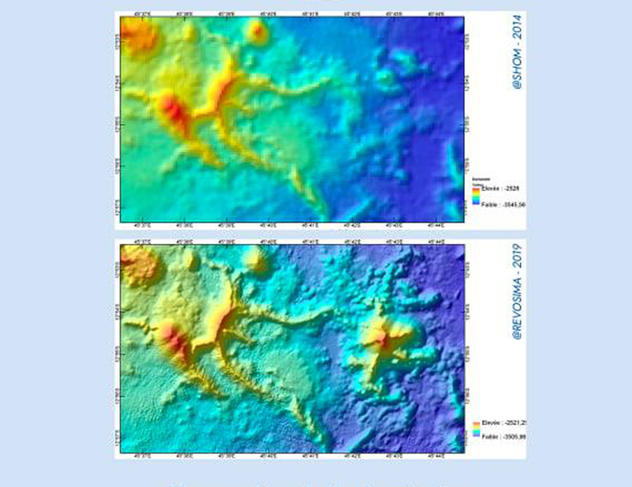
“Echo sounders on the ship’s bottom sent pulses of sound to the ocean floor: by recording how long it took for echoes to return to instruments on the ship, we could map the depths and shapes of the underwater terrain,” Bernard says.
“Comparing these maps to ones produced five years earlier during a French navy expedition, we saw that an 820 metre-high, five-kilometre-wide structure had appeared on the ocean floor.
“In a matter of months, a volcano half the size of Mount Vesuvius had grown on the deep seabed off Mayotte’s eastern coastline.
“Taken together, these observations enabled researchers to connect the birth of the new volcano with an active magma chamber deep in the Earth’s crust but closer to shore.
“As the lava was channelled towards the surface, it caused minor earthquakes as it moved, and then created a new volcano as it erupted on the seabed.”
New volcano raises pressing questions
The birth of the new volcano – named Fani Maoré – was the first time that scientists had monitored the evolution of a new underwater volcano as it was happening.
Figure 2
“We were still left with many open questions,” Bernard says. “Why did volcanic activity restart in the region after thousands of years? What was driving the activity? Was there more than one magma chamber? Was it empty now? What might happen next?
“One concern is that the seismic activity could trigger a tsunami.
“Another is that volcanic activity might shift closer to Mayotte, releasing hazardous gases such as sulphur dioxide closer to the shoreline.
“In a worst-case scenario, another edifice could emerge closer to the shoreline, which then raises the prospect of an eruption that could make landfall.
“At this point it may be necessary to stage an evacuation. We needed to be very open about what we knew and didn’t know and explore these different scenarios with authorities.”
Building a seafloor observatory
Observations taken during subsequent expeditions have shown a recent reduction in tremors and magma movement off the coast of Mayotte.
However, experts point out that volcanic activity often comes in bursts and a multi-year project to construct a permanent mobile and cabled seafloor and water column observatory has begun.
“The project unites the French research community in the development of observation techniques, infrastructure, and mobile equipment necessary for long-term, real-time observations to characterise and monitor the deep seabed,” explains Louis Geli, an expert on Earth and marine sciences, at the French National Institute for Ocean Sciences.
“Seismologists, volcanologists, oceanographers, biologists, chemists, and scientists from many other fields will have access to a multitude of datasets from instruments such as acoustic beacons, sea surface sensors, marine drones, seismometers, and hydrophones.
“It will enable them to observe seafloor deformation, eruptions, and volcano dynamics at depth, understand processes leading to the occurrence of volcanoes, earthquakes, and tsunamis, and to monitor aspects such as fluctuations in sea levels, swell, ocean and coastal dynamics, and marine biodiversity.”
One objective of the MARMOR project is to develop equipment that can be rapidly deployed should new flurries of seismic activity arise.
Another is the establishment of a deep-sea observatory, using a 76-kilometre-long network of fibre optic cables, and acoustic and optical sensors, at fixed stations, which will provide continuous, real-time data to a station on land.
“It’s essential that we continue to monitor the region, really understand what is happening, and focus on where the potentially dangerous places might be in the future,” says Geli, who is leading the installation of the observatory.
“Following the start of the volcanic activity, we were able to quickly develop approaches using autonomous equipment to look at what is happening in the water and on the seafloor.
“However, to develop timely warnings we need to collect and analyse data on events as they happen. The observatory will enable permanent real-time monitoring of seismic and volcanic activity in the deep-sea region above where the active magma chamber lies.
“Observations could support researchers in better understanding the path of magma and lava eruptions during volcanic activity, the shapes of the magma chambers, and how they connect with the surface.
“It will also provide a platform for research into a range of other areas, relating to deep-Earth processes and the resilience and recovery of marine life in the aftermath of eruptions.”
Challenges of the deep ocean
Geli adds that Mayotte’s seismic crisis illustrates the need to develop technologies to better explore the seafloor.
“Humankind has established permanent observatories at the north and south poles, in space, and yet the deep ocean is still a frontier to be conquered,” he says. “It is a high pressure and corrosive environment, making it extremely difficult to operate instruments for long durations.
“Making links between what we measure on the seafloor and probability of an eruption is a very complicated question. We don’t know exactly what to measure, or in many cases how to interpret the data, nor what the consequences might be.
“To fully understand seismic and volcanic processes requires years-long, high-sensitivity, multi-parameter time series observations.
“It’s a very difficult business to monitor volcanoes, earthquakes and tsunamis, but also very important, as the population at risk from the impacts of geohazards is growing.
“I hope that our work will go some way to filling in the many gaps in knowledge and support communities in responses commensurate with their threat.”
Header Image:The island of Mayotte seen from space | Credit: Copernicus Sentinel Data
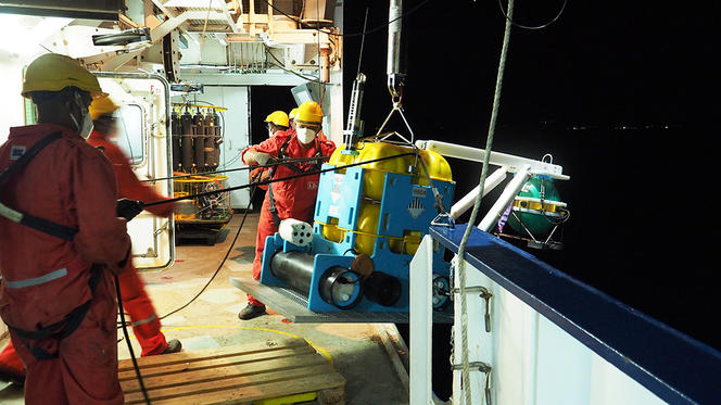
Figure 1: Aboard the “Marion Dufresne”, the crew is preparing to deploy a broadband OBS (Ocean Bottom Seismometer). Placed on the seabed and ocean floor, these seismometers record acoustic and seismic waves independently. (MAYOBS 15 Campaign, carried out by REVOSIMA from 1 to 27 October 2020). | Credit: REVOSIMA – MAYOBS15 (2020). https://image.ifremer.fr/data/00763/87468/
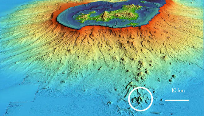
Figure 2: In May 2019, surveys revealed that the volcano, located 50 kilometres from the island, was around 800 metres high and exhibited intense activity at a depth of 3,500 metres. It can be seen here in the white circle on the eastern volcanic ridge. | Credit: MAYOBS – IPGP/CNRS/Ifremer/BRGM
More images available below – click to view full size and read captions:

 Geohazards