The Partnership for Observation of the Global Ocean (POGO) was founded in 1999 by directors of oceanographic institutions around the world as a forum to promote and advance the observation of the global ocean. POGO is a UK-registered charity with member institutions from around the world, and works closely with other international and regional programmes and organisations.
POGO seeks to expand international support for ocean observing, through innovation of the ocean observing system, capacity development and outreach/advocacy.
Researchers at the First Institute of Oceanography, Ministry of Natural Resources, China and their collaborators develop fixed ocean buoy systems aimed at unlocking mysteries of the Indian Ocean’s role in the Asian monsoon
On 14 August 2022, the China Meteorological Administration issued a rare red heat alert for provinces in the north and west of the country. The heatwave, which began several weeks earlier, had led to a crop-destroying, river-drying, record breaking drought from Henan in the west, to Xingjian in the northwest, to Shaanxi in the north. But just a year earlier, the same provinces were awash with record rainfalls, leading to flash floods that killed hundreds of people, displaced more than 100,000, destroyed homes and farmlands, and ruined livelihoods.
Meteorologists say that the effects of climate change on the Asian monsoon are making such unusual and devastating events much more likely. The monsoon – a phenomenon that famously inundates India with heavy rainfall each summer – plays a major role in weather and climate patterns across all of southeast Asia. Monsoon effects depend on a medley of local factors, including atmospheric conditions, proximity to the coast, and the topography of the land. But they are also shaped by events that happen much further away, driven by air, sea, and land interactions that span the continent as well as the Indian and Pacific Oceans – and beyond.
The Asian Monsoon – wind reversal on a continental scale
“The Asian monsoon influences weather and climate from the Arctic Circle to the tropics and directly impacts roughly half the world’s population,” explains Weidong Yu, a researcher at Sun Yat-sen University in Zhuhai. “Every year, seasonal changes in prevailing wind direction drive well-defined weather patterns. Broadly speaking this leads to wet summers and dry winters, but there are significant variabilities at the regional level. Some of the most common natural disasters such as droughts and cyclones are frequently connected to the monsoon climate.
“At a global level, the extent of the Asian monsoon is one of the most difficult weather phenomena to predict. Southern and Eastern Asia are the most densely populated regions on Earth, and therefore this unpredictability presents substantial challenges from a disaster mitigation point of view.
“There is no doubt that climate change is making this challenge even harder by influencing the nature of monsoon patterns. It is therefore essential that we better understand, analyse, and model the underlying factors that can make the monsoon stronger or weaker, or more or less predictable. Our societies and economies heavily rely on this information.”
To understand how changes in the atmosphere thousands of miles away might impact the weather in China, forecasters can bring together observations taken by satellites, planes, balloons, and weather stations. Yet there are far fewer measurements taken in situ in the ocean, despite the massive role that the seas play in the Asian monsoon. “The Indian Ocean is warming faster than any other ocean, but little is known about decadal variations, for example,” Yu says. “This makes it difficult to distinguish climate change trends from patterns of natural variability or to understand changing biogeochemistry at these timescales.”
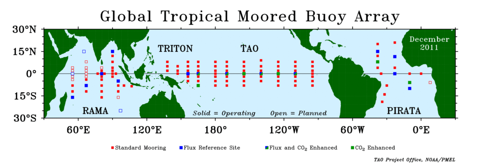
Ambitious projects such as theIndian Ocean Observing System aim to change this by coordinating research efforts at an international level. “Approaches include research cruises, robotic instruments that drift with the ocean currents called Argo floats, and gliders that return a wealth of important datasets. Our work, however, is centred on a network of remarkable moored buoys anchored to the seabed called Bailong buoys. They form part of the Research Moored Array for African-Asian-Australian Monsoon Analysis and Prediction (RAMA),” explains Yu, who led the development of Bailong buoys (see figure 1).
FIG 1
China’s first deep-ocean climate observation buoy system
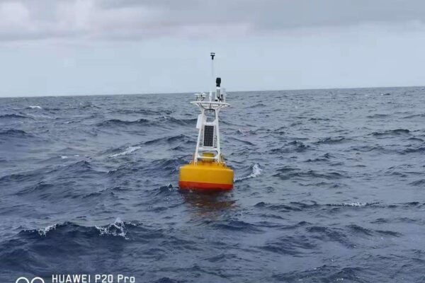
Some 5000 metres down in the abyss of the Indian Ocean seems a world away from the sun-soaked plateaus of northern China. But it is here, amidst the crushing pressures and murky darkness that the deepest of China’s Bailong buoys is anchored to the seabed. First deployed in 2010 by the First Institute of Oceanography (FIO), based in Qingdao, the Bailong Buoy joins similar initiatives by the US and Japan as a third type of deep ocean climate observation buoy system. Now the buoys can be found dotted across the open ocean, as well as off the coast of Indian Ocean countries such as Thailand, Malaysia, and Kenya.
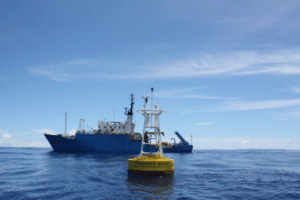
FIG 2
With multi-element sensors and high-frequency sampling, Bailong buoys provide continuous, real time data including surface winds speeds, surface air humidity, pressure, rainfall, sunshine duration and oceanic current, temperature, salinity,. “The operation of deep ocean buoys is very challenging and international collaboration and technology transfer are very important for us,” Yu explains. “Information is transmitted up through wires to the buoy controller, where data is then sent to our institute via satellite link. The whole system needs to be set up in a way that preserves energy when possible, while maintaining the flow of real-time data. It needed a very smart strategy to work, but we made it.”
As well as providing invaluable information for weather and climate predictions, data provided by the buoy network also helps researchers shine light on the relationship between the Asian monsoon and other weather phenomena. This includes intricate relationships between the Asian, African, and Australian monsoons, which are thought to be part of a wider climate system.
These studies are supported by international collaborations, such as between FIO, the Qingdao National Laboratory for Marine Science and Technology, and Australia’s Commonwealth Scientific and Industrial Research Organisation (CSIRO). In 2018, an international team of scientists deployed a set of Argo floats and Bailong buoys in the tropical southeast Indian Ocean. “This is an area that plays a key role in the onset of the Australian monsoon,” says Liu Lin, an ocean expert at the FIO’s Centre for Ocean and Climate Research. “The ocean can be very rough, and equipment needs to be able to weather rough seas for long periods of time. But the teams deploying the buoys also have to battle with other obstacles, such as severe bouts of seasickness.”
But perhaps the greatest challenge comes from maintaining the flow of precious data. For more than a year, Bailong buoys provided priceless observations of the dynamics of upper levels of the ocean.
But on 1 June 2019, the regular GPS signals the team were receiving from the buoys suddenly stopped.
“A technician eventually managed to geolocate the buoy hundreds of kilometres away from where we moored it,” explains Lin. “Teams were deployed to rescue the instruments from the ocean. Thankfully, the ship crew tracked down the buoy and sent us pictures of the body system: we could see that the steel wire had been sliced straight through.”
Lin says that on this occasion the damage was likely the result of an unlucky encounter with a fishing boat. But the episode shone a light on the challenge of not only expanding observations in the open ocean, but also ensuring their continuity. “Such incidents are a huge problem, and if the body of the buoy becomes separated from the wire, we may only have a fifty-fifty chance of retrieving it,” Liu explains.
“In the past, many parts of the Indian Ocean have had very few in situ observations: satellites cannot see beneath the ocean surface, while Argo floats cannot provide long-term measurements at specific locations. Buoys provide a backbone with high frequency and high efficiency observations that are directly comparable over time, because they are taken from a fixed point. Maintaining a constant flow of data is crucial.
“Over time we can build up first-hand datasets to learn about the state of the ocean now, so that we can compare to the past, and try to make predictions about how it might change in the future. For example, researchers can apply statistical and numerical approaches to learn about internal ocean mechanisms. If we see there has been unusual warming, these data can help us to understand whether what we are seeing is a one off or part of a regular pattern – and to predict what the implications may be for the monsoon season.”
It can also support near-term and seasonal weather forecasts. “Numerical weather prediction models rely on bringing together large and diverse real time datasets on the state of the environment now to make predictions about how weather will change over the coming days,” Lin explains. “This is especially important given the influence of the Indian Ocean on broader weather patterns. More data means more accurate forecasts, which are crucial for everything from agriculture, to the economy, to public safety.”
Meeting future challenges
Like global weather patterns driven by El Niño and La Niña in the Pacific Ocean, the Indian Ocean also has periods where anomalous sea surface temperatures warm or cool respectively, impacting the climate in many other parts of the world, known as the Indian Ocean Dipole. Lin’s mission is to better understand this phenomenon and its potential impacts elsewhere. “The ocean stores vast quantities of solar energy that can feedback to the air and atmosphere,” he explains.
“Changes in the ocean can change climate systems, especially in the long term. To make sense of these changes we need to understand what is happening at different timescales, including daily, seasonal, interannual, and decadal.
This is what makes long-term time series measurements from fixed ocean buoys so important: it gives us a chance to really understand the mechanisms underlying how the Indian Ocean moderates the monsoon and influences its onset.
“Many areas in southeast Asia are still developing and for these places it is crucial to continue to develop ocean science and increase our ocean observation capacities. There is a long way to go: we have built up a system to provide us data, now we need to analyse it and better understand what is happening. This will put us in the best possible position to mitigate disasters or the negative effects from climate variability and climate change.”
Photo credits:
Main image: Photo courtesy of Qingdao National Laboratory for Marine Science and Technology (QNLM)
Figure 1: TAO Project Office, NOAA, PMEL
Figure 2: Image courtesy of Weidong Yu
Written by Adam Gristwood
With thanks to Weidong Yu (Sun Yat-sen University, Zhuhai) and Liu Lin (FIO’s Centre for Ocean and Climate Research)

 Climate-critical observing